
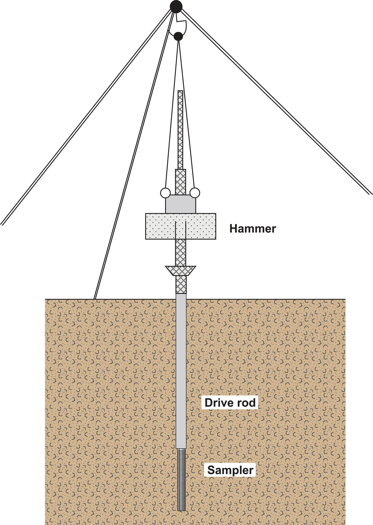
Standard Penetration Test
IS:1892
I. SCOPE
1.1 This code deals mainly with subsurface investigations for foundations of
multi-storeyed buildings to determine,
a) Sequence and extent of each soil and rock stratum in the region
likely to be affected by the proposed work,
b) Nature of each stratum and engineering properties of soil and rock
which may affect design and mode of construction of proposed
structures and their foundations, and
c) Location of ground water and possible corrosive effects of soil and
water on foundation materials. .
1.1.1 Aspects relating to procuring representative samples of the soils and
rocks, obtaining general information on geology, seismicity of the area,
surface drainage, etc, and subsurface investigations for availability of construction materials are also mentioned briefly.
1.13 Most of the provisions of this code are also applicable to subsurface
investigation of underground and overhead water tanks, swimming ~001s
and ( abutments of) bridges, roads, air fields, etc.
2. GENJSRAL
2.1 In areas which have already been developed, advantage should be taken
of existing local knowledge, records of trial pits, bore holes, etc, in the
vicinity, and the behaviour of existing structures, particularly those of a
nature similar to that of the proposed structure. In such cases, exploration
may be limited to checking that the expected soil conditions are those as in
the neighbourhood.
2.2 If the existing information is not sufficient or is inconclusive the site
should be explored in detail so as to obtain a knowledge of the type,
uniformity, consistence, thickness, sequence and dip of the strata and of the
ground water conditions.
2.2.1 Site Reconnaissance - Site reconnaissance would help in deciding
future programme of field investigatiofis? that is, to assess the need for
preliminary or detailed investigations. This would also help in determining
scope of work, methods of exploration to be adopted, field tests to be
carried out and administrative arrangements required for the investigation.
Where detailed published information on the geotechnical conditions is not
available, an inspection of site and study of topographical features are helpful in getting information about soil, rock and ground-water conditions.
Site reconnaissance includes a study of local topography, excavations,
ravines, quarries, escarpments; evidence of erosion or landslides, behaviour
of existing structures at or near the site; water level in streams, water courses
and wells; flood marks; nature of vegetation; drainage pattern, location of
seeps, springs and swamps. Information on some of these may be obtained
from topographical maps, geological maps, pedological and soil survey
maps, and aerial photographs.
2.2.1.1 Data regarding removal of overburden by excavation, erosion
or land slides should be obtained. This gives an idea of the amount of
pm-consolidation the soil strata has undergone. Similarly, data regarding
recent f?lls is also important to study the consolidation characteristics of the
fill as well as the original strata.
2.213 The type of flora affords at times some indication of the nature
of the soil. The extent of swamp and superficial deposits and peats will
usually be obvious. In general, such indications, while worth noting, require
to be conflrmed by actual exploration.
d will depend upon the permeability ‘of the strata and the head causing
the water to flow. The water level in streams and water courses, if any, in
the neighbourhood, should be noted, but it may be misleading to take this
as an indication of the depth of the water table in the ground. Wells at
the site or in the vicinity give useful indications of the ground-water conditions. Flood marks of rivers may indicate former highest water levels.
Tidal Auctuations may be of importance. There is also a possibility of
there being several water tables at ditferent levels, separated by impermeable
strata, and some of this water may be subject to artesian head.
2.2.2 Enquiries Regarding Eatlfer Use of the Site - In certain cases the
earlier uses of the site may have a very important bearing on proposed new
works. This is particularly so in areas.where there have been underground
workings, such as worked-out ballast pits, quarries, old brick fields, coal
mines and mineral workings. Enquiries should be made regarding the
location of shafts and workings, particularly shallow ones, where there
may be danger of collapse, if heavy new structures are superimposed.
2.2.2.1 The possibility of damage to sewers, conduits and drainage
systems by subsidence should also be investigated.
2.2.3 Geophysical investigations of the site may be conducted at the
reconnaissance stage since it provides a simple and quick means of getting
useful information about stratifications. Depending on these information,
detailed subsoil exploration should -be planned. Important geophysical
methods available for subsoil exploration are:
a) electrical resistivity method, and
b) seismic method.
2.2.3.1 Electrical resistivity methdd - The electrical resistivity method,
in which the resistance to the flow of an electric current through the subsurface materiaIs is measured at intervals of the ground surface, may be useful
for the study of foundation problems and particularly for finding rock strata
under deep soil cover.
2.2.3.2 Seismic method - The seismic method makes use pf the variation
of elastic properties of the strata which affect the .velocity of shock waves
travelhng through them, thus providing a usable tool for dynamic elastic
moduli determinations in addition to the mapping of the subsurf’ horizons. The required shock waves can be generated by hammer blows on the’
ground or by detonating a small charge of explosives. This method is quite
useful in delineating the bedrock configuration and the geological structures
in the subsurface.
2.3 Outline of Procedure
2.3.1 Number and Disposition of Trial Pits and Borings - The disposttion
and spacing of the trial pits and borings should be such. as to reveal any major changes in thickness, depth or properties of the strata over the base
area of the structure and its immediate surroundings. The number and
spacing of bore holes or trial pits will depend upon the extent of the site
and the nature of structures coming on it. For a compact building site
covering an area of about 0.4 hectare, one bore hole or trial pit in each
corner and one in the centre should be adequate. For smaller and less
important buildings even one bore hole or trial pit in the centre will suffice.
For very large areas covering industrial and residential colonies, the geological nature of the terrain will help in deciding the number of bore holes or
trial pits. Cone penetration tests may be performed at every 50 m by dividing the area in a grid pattern and number of bore holes or trial pits decided
by examining the variation in the penetration curves. The cone penetration
tests may not be possible at sites having gravelly or boulderous strata. In
such cases geophysical methods may be useful.
2.3.2 Depth of Exploration - The depth of exploration required depends
on the type of proposed structure, its total weight, the size, shape and
disposition of the loaded areas, soil profile, and the physical properties of
the soil that constitutes each individual stratum. Normally, it should be
one and a half times the width of the footing below foundation level. In
certain cases, it may be necessary to take at least one bore hole or cone test
or both to twice the width of the foundation. If a number of loaded areas
are in close proximity the effect of each is additive. In such cases, the
whole of the area may be considered as loaded and exploration should
be carried out up to one and a half times the lower dimension. In weak
soils, the exploration should be continued to a depth at which the loads
can be carried by .the stratum in question without undesirable qettlement
and shear failure. In any case, the depth to which seasonal variations
affect the soil should be regarded as the minimum depth for the exploration
of sites. But where industrial processes affect the soil characteristics this
depth may be more. The presence of fast growing and water seeking trees
also contributes to the weathering processes.
NOTE - Examples of fast growing and water seeking trees are Banyan ( Fkus
ben&nsis ), Pipal ( Ficus religiosa ) and Necm ( Azadirachta indica ).
2.3.2.1 An estimate of the variation with depth of the vertical normal
stress in the soil arising from foundation loads may be made on the basis of
elastic theory. The net loading intensity at any level below a foundation
may be obtained approximately by assuming a spread of load of two vertical
to one horizontal from all sides of the foundations, due allowance being
made for the overlapping effects of load from closely spaced footings. The
depth of exploration at the start of the work may be decided as given in
Table 1, which may be modified as exploration-proceeds, if required.
2.4 Importance of Ground-Water Tables
2.4.1 For most types of construction, water-logged ground is undesirable
because of its low bearing capacity. On sites liable to be water-logged in
wet weather, it is desirable to determine the fluctuation of the water table
in order to ascertain the directions of the natural drainage, and to obtai.n
a clue to the design of intercepting drains to prevent the influx of ground
water on to the site from higher ground. The seasonal variation in the
. level of water table should also be noted.
2.4.2 If in the earlier stages of investigations, dewatering problems are
anticipated a detailed study should be carried out to ascertain the rate of
flow and seepage.
2.4.3 For deep excavation, the location of water-bearing strata should be
determined and the water pressure observed in each, so that necessary precautions may be taken during excavation, for example, artesian water in
deep strata may give rise to considerable difficulties unless precautions are
taken. An idea of the steady level of water should be obtained. Bore
holes, which have been driven, may be used for this purpose, but since water
levels in bore holes may not reach equilibrium for some time after boring,
these should be measured 12 to 24 h after boring and compared with water
levels in wells that may be available in the area. It is seldom necessary
to make detailed ground-water observations in each one of a group of
closely spaced bore holes but sufficient observations should be made to
establish the general shape of the ground-water table; however, observations
should always be made in the first boring of the group. The minimum
and maximum ground-water levels should be obtained from local sources
and wells in the area would also give useful information in this regard.